Another day off from work, another hike. A friend of mine, Trevor, agreed to go with me.  Because this was his first hike of the year and his first "Elevener" I thought I better make it one on the easier side of the scale. Little did I know, the information I had on the Red Baldy hike was a little off.
We arrived at the White Pine trail head up the Little Cottonwood Canyon at about 8:00 and started down the trail about 8:05. I had hiked the first mile of the hike only a little over a week earlier on my way up to Red Pine lake and Pfeifferhorn.
Once we arrived at the split in the trail (straight ahead leads to Red pine Lake and left to White Pine lake), we followed the trail which makes a sharp switchback to the left. It appeared that there used to be a sign here as witnessed by a log post sticking up out of the ground with a notch for a sign. But no sign was present. The first part of the trail heads in an easterly direction and follows an old mining road.
The road switches back through Pine forests, meadows, and boulder fields, and crosses a few streams, some of which run down the road for a few yards.
After about 4 miles and walking thought a large boulder field at 10,000 feet, you leave the road and route find the rest of the way up to a spur ridge that runs up to the main ridge. One marking that helps know where to turn off is an overgrown road that breaks off briefly on the left and switches back until it ends not far after it begun into a small drainage.
You actually want to start up the drainage and, once past a steeper section off to the left, you want to head left, aiming for the last bunch of trees way up near the Red Baldy ridge. This last part of the hike is considerably more steep, covering 1100 feet in about a half a mile. Once there, it’s a short hike over stable black rocks to the summit.
We made it to the summit at about 11:20 (including an accidental .5 mile excursion to White Pine lake. Note: if you can see the lake from the road, you’ve gone too far. You won’t see it until you’ve started the final ascent up the drainage).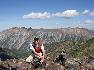
After a few pictures, a couple of granola bars, and a total of 30 minutes taking in the views, we decided to head back down. We made it back to the car about 2:15 just as some afternoon storm clouds appeared to be blowing in.
It was a challenging hike that had pretty scenery and a somewhat challenging final ascent to the summit. In total, it was 10.3 miles and took us 6 hours and 17 minutes to complete.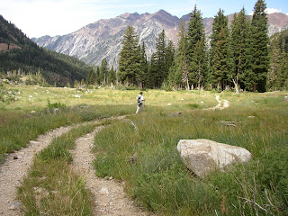
 Because this was his first hike of the year and his first "Elevener" I thought I better make it one on the easier side of the scale. Little did I know, the information I had on the Red Baldy hike was a little off.
We arrived at the White Pine trail head up the Little Cottonwood Canyon at about 8:00 and started down the trail about 8:05. I had hiked the first mile of the hike only a little over a week earlier on my way up to Red Pine lake and Pfeifferhorn.

Once we arrived at the split in the trail (straight ahead leads to Red pine Lake and left to White Pine lake), we followed the trail which makes a sharp switchback to the left. It appeared that there used to be a sign here as witnessed by a log post sticking up out of the ground with a notch for a sign. But no sign was present. The first part of the trail heads in an easterly direction and follows an old mining road.
The road switches back through Pine forests, meadows, and boulder fields, and crosses a few streams, some of which run down the road for a few yards.
After about 4 miles and walking thought a large boulder field at 10,000 feet, you leave the road and route find the rest of the way up to a spur ridge that runs up to the main ridge. One marking that helps know where to turn off is an
 overgrown road that breaks off briefly on the left and switches back until it ends not far after it begun into a small drainage.
You actually want to start up the drainage and, once past a steeper section off to the left, you want to head left, aiming for the last bunch of trees way up near the Red Baldy ridge. This last part of the hike is considerably more steep, covering 1100 feet in about a half a mile. Once there, it’s a short hike over stable black rocks to the summit.
We made it to the summit at about 11:20 (including an accidental .5 mile excursion to White Pine lake. Note: if you can see the lake from the road, you’ve gone too far. You won’t see it until you’ve started the final ascent up the drainage).

After a few pictures, a couple of granola bars, and a total of 30 minutes taking in the views, we decided to head back down. We made it back to the car about 2:15 just as some afternoon storm clouds appeared to be blowing in.
It was a challenging hike that had pretty scenery and a somewhat challenging final ascent to the summit. In total, it was 10.3 miles and took us 6 hours and 17 minutes to complete.


No comments:
Post a Comment